Verdict de Chart Police · 9 octobre 2026
When did your country became a country?
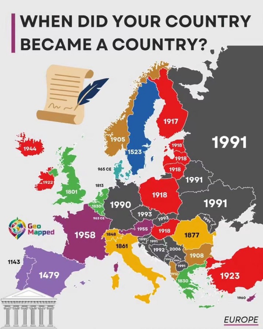
This is a popular, decorative 'fun fact' map whose dates mix incompatible events (independence, republic founding, unification, medieval origins) under one vague title. With no legend and no criteria, the dates cannot be compared across countries, and some, like France 1958, are misleading as answers to when a country became a country.
Constats
Inconsistent and arbitrary definition of 'became a country'
Titre, étiquettes ou annotations trompeurs · grave · confiance 80 % · +43.2 points · Country labels across the whole map
The dates mix different events: independence (Ireland 1922, Norway 1905), a new constitution or republic (France 1958, from the Fifth Republic), reunification (Germany 1990), unification (Italy 1861), and medieval origins (Denmark 965 CE, Spain 1143/1479). France is shown as 1958 although it existed as a state for over a thousand years, while Denmark gets 965 CE. Germany 1990 ignores 1871 and the earlier states. The title never says which event counts.
Selective choice of dates and omitted histories
Période choisie ou données omises · modéré · confiance 55 % · +14.9 points · Eastern Europe and the Balkans
The labelled year ignores earlier statehood. Russia, Ukraine and Belarus are all shown as 1991 (Russia as a state is centuries older). Several Balkan states are shown with different dates (1991, 1992, 2006, 2008), with the Kosovo and Montenegro labels tiny and hard to read. The choices push a 'newness' narrative inconsistently.
No legend or explanation of colors, and the source and criteria are missing
Contexte manquant · modéré · confiance 75 % · +11.2 points · Whole map; no legend
Countries are filled with red, green, purple, orange, brown, blue, teal and dark gray, but no legend explains what the colors mean. Some countries carry two dates (Spain 1143/1479, Belgium 1813/1830, Italy 1848/1861) without explanation. No source is given beyond the 'GeoMapped' logo.
Categorical colors do not follow the date order
Échelle de couleurs trompeuse · mineur · confiance 50 % · +5 points · Map fill colors
Colors are not a sequential scale: 1918 is red for Poland and Hungary, but 1917 (Finland), 1922, 1923 and 1944 are also red, while 1991 is dark gray. Similar-looking hues stand for very different eras, which makes the map hard to read as a timeline.
Comment le corriger
State one clear criterion, such as the date of current independence or sovereignty, and apply it consistently to every country, noting alternatives in footnotes. Add a legend for the colors (for example, a sequential scale by century) and cite a source.